

Ancient India which is known for many characteristics of Indian society . To understand ancient India or the history of India, we have to understand the geographical structure of India . The Indian subcontinent, a vast landmass of South Asia, is home to one of the world’s oldest and most influential civilizations.
The geography of an ancient Indian country plays an important role in determining the historical events of that country . The influence of geographical factors can also be seen in shaping the history of India . Geographically, the Indian Subcontinent includes five countries: India, Pakistan, Bangladesh, Nepal, and Bhutan . The Indian subcontinent is a well-defined unit that can be divided into 3 regions .
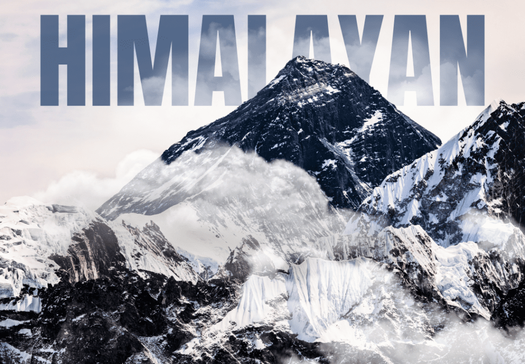
First Region: Himalayan mountain ranges(Ancient Indian)
Here are some of the highest mountains in the world. The average width of the Himalayan mountain range is 240 to 320 km, and its length from east to west is about 2560 km. It acts as a natural wall to the Indian subcontinent and protects the country from the cold Siberian wind coming from Central Asia.
Due to this, the weather in Northern India remains hot throughout the year. The Himalayan region is usually covered with snow in winters, due to which it is impossible to cross it in winter. The Central Himalayan mountain ranges, which extend from Bhutan to Chitral, border the great plateau of Tibet. Trade and other types of relations between India and Tibet continued through this border region.
For a long time it was believed that the Himalayas served as a natural boundary to protect India from invasions, but this is not entirely true because Khyber, Bolan, Kurram, and Gomal, some of the important mountain passes in the north-west, had been used to cross the Himalayas. This pass is located in the Hindukush, Sulaiman, and Kirthar mountain ranges.
Through this route, India could be easily reached from Central Asia and Persia. The Khyber Pass and other passes and the Kabul River connect the region to the Indus plains. Even in prehistoric times, people were constantly coming and going through these passages.
Through these routes, many people came to India as invaders and migrants. Such as Indo-Greeks, Persians, Shakas, Kushan, Hua, Turks, Mughals, etc had attacked India through the passage. It was not that only the attackers came to India through these passages; many Buddhist scholars have also used their passes to propagate their religion.
Whatever evidence we see of Buddhism today in Bamiyan in Afghanistan or in Central Asia, all that was possible only through the routes provided by these mountain passes. Apart from this, this passage would also provide trade routes for India and Central Asia. In ancient and medieval times, there was continuous trade through these routes; hence, we can say that such passes also facilitated trade and cultural ties between India and central Asia.
The Himalayas reach as far east as Assam. Important mountains of this region are Patkai Bam, Nagai, and Lushai. These hills are covered with dense forests and remain mostly inaccessible due to heavy rainfall. The mountains of North East India are difficult to cross, leaving many parts of the region isolated from the mainland of the Indian subcontinent. But despite this, people from Tibet, China, Myanmar, Bengal, and Bihar kept coming here. Over time, the tribal community living here gave rise to the distinct culture of the North East. The Ahom Empire was a famous empire here that fought hard against the Mughals to maintain its separate political and cultural identity.
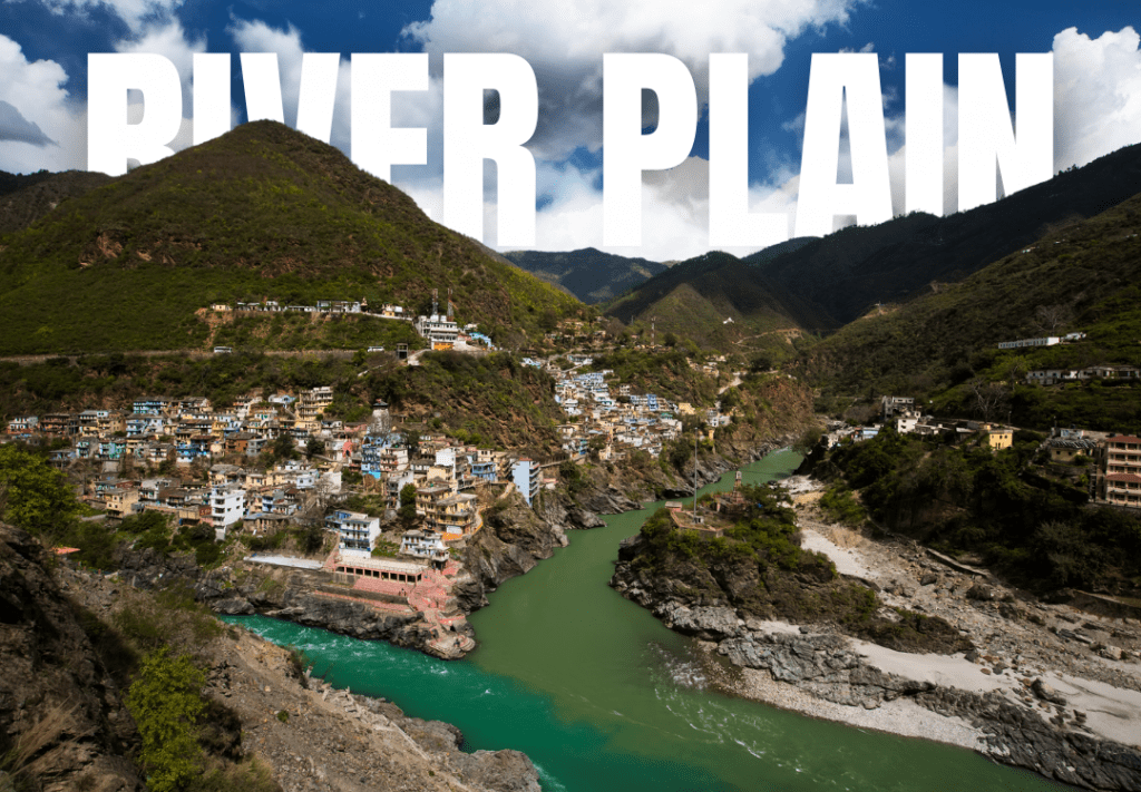
Second Region: Indus Ganga Brahmaputra Plain
South of the Himalayan mountain range, the Indus, Ganges, and Brahmaputra rivers have created a vast plain in India. It is one of the most fertile plains in the world due to the alluvial soil brought by the Indus, Ganga, and Brahmaputra rivers and their tributaries . Both the Indus and Ganga rivers originate from the Himalayas, out of which the Indus river originates from the Himalayas and flows towards the west and joins the Arabian Sea. Jhelum, Chenab, Ravi, Sutlej, and Beas are its major tributaries. The fertile plain of Punjab is formed by the Indus river system. Punjab (currently divided between India and Pakistan) literally means the land of five rivers. The Indus River Plain is known for its fertilize soil.
India’s first urban civilization, the Harrappan civilization, was developed near the Indus River valley. East of the Indus River, the Gangetic Plain is formed by the Ganges and its tributaries. The Ganga and its tributary Yamuna, originating from the Himalayas, meet near Prayag and form the Doab. This is an ancient upland plain. It was in the plains where Vedic Sanskriti was first developed. The plains of Ganga played an important role in the development of urban centers in North India. Most of the 16 Mahajanapadas developed in the fertile gangetic plains in 600 BCE. Magadh, under the Mauryan Dynasty, was also developed in the Ganga river basin. Apart from this, Banaras, Prayagraj, Agra, and Delhi are some of the great cities situated in the plains of Ganga. Among these, Delhi, situated at the western end of the Ganga plain, is the most important city. Most of the decisive battles of Indian history, such as kurukshetra, train, and panipat, were fought around Delhi because this plain has always been a source of temptation and attraction for foreign invasions due to its fertility and productive wealth. Many battles were fought from ancient times to medieval times to gain control over the Ganga Yamuna gates.
In the east, the Ganga plain meets the Brahmaputra plain. The brahmaputra originates from the Himalayas and, after flowing through Tibet, enters India through Arunachal Pradesh. The Ganga Brahmaputra plain extends from Assam to Bengal. Adjacent to the plains of Bengal is the vast Assam valley formed by the Brahmaputra. It is spread over an area of more than 600 kilometers. Rice has been cultivated in the fertile soil here. Culturally, Assam is close to Bengal. But from the point of view of historical development, this state is a late state in the development process, like Odisha. From ancient times, it was difficult for the states of North India to maintain control over Bengal due to the flood conditions created during the monsoon.
Apart from this, during the rainy season this area used to turn into marshy land. The invading armies had to face a lot of difficulties in maintaining their morale. That is why we see that the governor, who was sent from Delhi to Bengal, often established his independent power in Bengal. This led to the development of the Bengali language and distinct culture in Bengal, separate from North India. The Indus, Ganga, and Brahmaputra and their tributaries served as arteries for trade and transportation in the region.

Third Region: Southern Peninsula
Vindhya and Satpura mountains with Narmada and Tapti rivers divide Northern and Southern India. The plateau to the south of the Vindhya mountain is called the Deccan plateau, which was formed by volcanic eruption. The Deccan Plateau is surrounded on both sides by the Eastern Ghats or Western Ghats mountain ranges.The Deccan Plateau is divided into four major parts. These parts fall in the states of Maharashtra, Andhra, Telangana, and Karnataka. To the west of the Western Ghats is a narrow strip of coastal plains, called the Konkan Coast from Gujarat to Goa or the Malabar Coast from Goa to Kerala. This type of coastline is also formed in the east of the Eastern Ghats, whose thickness is greater than that of the Western Ghats. This coast from Orissa to Andhra Pradesh, Northern Government, and Tamil Nadu is called the Coromandel Coast. The western coastal plain also extends far south up to Malbar. Today we know this region as Kerala. Apart from paddy and other crops, black pepper and other spices were also grown in Kerala at that time. Kerala has been trading these spices with the West since the post-Maurya period. Relatively isolated by land, the state of Kerala is completely open to the sea. It is an interesting truth that Christian influence and later Muslim influence in India came through the sea.
Physical relief, the slope of the river, and the climatic conditions played the most important role in shaping the historical events of southern India. Although the dense forests of Vidyalaya Chal and Satpura separate it from North India due to geographical differences, the Deccan Plateau serves as a bridge between North and South India. Tamil, Telugu, Malayalam, Kannada, and Sanskrit developed in South India, which is distinct from North India. Important rivers from the Southern Peninsula flow almost parallel to each other. The Mahanadi, which originates at the eastern end of the peninsula of India, falls into the basin of Bengal, while the Narmada and Tapti flow from the east towards the west and join the Arabian Sea. Other major South Indian rivers like Godavari, Krishna, Tungabhadra, and Kaveri flow from west to east.
In the history of South India, the area between Krishna and Tungabhadra, which is called Raichur Doab, has been the main center of dispute between the states of South India. The Chalukyas and Pallavas fought for control of the region from the 6th to the 8th century, and the Vijayanagara and Bahmanis fought for control of the region from the 14th to the 16th century. Due to the long coast of peninsular India, South India has been carrying out maritime trade with various countries since ancient times. The Chola Empire not only established trade relations with countries like Jawa, Sumatra, Burma, and Cambodia, but they also spread the religion and culture of India, evidence of which we can still see today in Angkor Wat and Borobudur. South India established trade and cultural ties with Rome, which can be witnessed in the Roman settlement of Arikamedu .
Conclusion
Thus, we can say that the geographical location of India has played an important role in shaping the history of India . The Himalayan mountains covered with snow or dense forests located in the north of India not only provide natural security to India, but the rivers originating from them also make the vast plains of the north fertile. Human civilization has been living on the banks of these rivers for centuries. Vindhyachal or Satpura Mountains separate Northern India from Southern India, due to which the social culture or political influence of Northern India is less in Southern India. Southern India also witnessed the development of a specialized Dravidian culture. All these natural phenomena have divided India into different regions, which have their own distinct culture, social customs, traditions, languages, and histories. The history of India has evolved from a combination of the histories of these different regions.
Every type of climate is found in India, from polar to temperate and tropical. In the higher areas of Uttar Pradesh, there is snowy air and snowy weather, while in the plain areas of Rajasthan, there is a scorching sun and heavy dust storm. Coastal areas face hurricanes every year, while the north-eastern states receive some of the world’s highest rainfall, due to which we get evergreen rain forests.


0 Comments